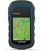
Print perfect, spend less
To see product details, add this item to your cart. You can always remove it later.
Ships from
Ships from
Returns
Eligible for Return, Refund or Replacement within 30 days of receipt
This item can be returned in its original condition for a full refund or replacement within 30 days of receipt.
Payment
Secure transaction
Your transaction is secure
We work hard to protect your security and privacy. Our payment security system encrypts your information during transmission. We don’t share your credit card details with third-party sellers, and we don’t sell your information to others. Learn more
Added to

Sorry, there was a problem.

There was an error retrieving your wish lists. Please try again.

Sorry, there was a problem.

List unavailable.
About the introduction of ZL190NiesahYan
  • ZL190 Handheld GPS for Surveying, High Precision Rugged Land Surveying Equipment for Mountainous ,Sloping Fields,Ranches, Garden, Farmland, Parking Area and Distance
  • To view this video, download
  • 3 VIDEOS

ZL190 Handheld GPS for Surveying, High Precision Rugged Land Surveying Equipment for Mountainous ,Sloping Fields,Ranches, Garden, Farmland, Parking Area and Distance

4.1 out of 5 stars (24)

To see product details, add this item to your cart. You can always remove it later.

Purchase options and add-ons

  • ACCURATE: Great support 4 high precision satellite system,GPS+BEIDOU+GLONASS+QZSS ,strong satellite signal, small measurement errors, area measurement error in 0.002 acres
  • 3.2'' LARGE SCREEN: Equipped with TFT backlit display allows measurements to be easily read, even in dark areas
  • MULTIPLE MEASUREMENT MODES: Can measure the area of any terrains like farmland,gardens, parking lots, and pastures, just need to walk around to get the area of the terrain,also support measure distance and slope
  • DURABLE DESIGN: IP65 waterproof strong dust-proof function.Portable design, fits in your hand or pockets perfectly, equipped wrist strap lets you hold the meter steady and carry
  • WHAT YOU GET: 1x GPS Surveying Equipment, 1x User Manual, 1x Charge Cable, 1x Hand Strap. 2 year manufacture.Please be sure to read the User Manual carefully before operating
  • !!! PLEASE NOTE:The GPS Land Meter must be used outdoors with an unobstructed view of the sky and the screen facing upward,and this machine can only be used for surveying and cannot be used for navigation!
  • Tips: Recommended to measure an area above 0.16 acres and distance above 328 ft. The larger the measurement range, the smaller the error

Frequently bought together

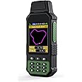
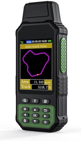
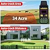
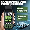
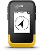
This item: ZL190 Handheld GPS for Surveying, High Precision Rugged Land Surveying Equipment for Mountainous ,Sloping Fields,Ranches, Garden, Farmland, Parking Area and Distance
$156.44
Get it by Tuesday, Feb 3
In Stock
Sold by NiesahYan and ships from 鶹 Fulfillment.
+
Total price:$00
To see our price, add these items to your cart.
Details
Added to Cart
Choose items to buy together.
Brief content visible, double tap to read full content.
Full content visible, double tap to read brief content.

Videos for similar products

Product information

Technical Details

Manufacturer ‎NiesahYan
Product Dimensions ‎2.54 x 5.08 x 17.78 cm; 222.26 g
Item model number ‎ZL190
Colour ‎Green
Material ‎Plastic
Power Source ‎Battery Powered
Included Components ‎Portable Rope, Power Adapter, USB Cable, User Manual
Batteries Included? ‎No
Batteries Required? ‎No
Item Weight ‎222 g

Additional Information

ASIN B0DQZ7HCL4
Customer Reviews
4.1 out of 5 stars (24)

4.1 out of 5 stars
鶹 Rank
Date First Available March 25 2025

Feedback

ZL190 Handheld GPS for Surveying, High Precision Rugged Land Surveying Equipment for Mountainous ,Sloping Fields,Ranches, Garden, Farmland, Parking Area and Distance


Found a lower price? Let us know. Although we can't match every price reported, we'll use your feedback to ensure that our prices remain competitive.

Where did you see a lower price?

Price Availability
/
/
/
/
Please sign in to provide feedback.

Product Description

1
1

How to use ''Auto-track Area" ?


You can use this method to measure irregular terrain area, such as mountains, sloping fields, ranches and garden.First,please search satellite signals in an open outdoor area before using this device,there is no signals can be searched indoors.When the signal value in the upper left corner of the machine screen is below 1 m, start using to ensure the accuracy of the machine.

The video showcases the product in use.The video guides you through product setup.The video compares multiple products.The video shows the product being unpacked.

Auto Track Area Measurement

Merchant video
1

What you should know before buying:

  • This tool needs a clear, open view of the sky (no trees, roofs, or obstructions) and must be placed screen-side up to lock onto satellites. Try moving to an open field or away from tall structures.

  • No, this is a professional surveying tool only. It’s not designed (or accurate enough) for road navigation, marine use, or hiking. Stick to land measurement tasks!

  • We recommend measuring at least 0.16 acres or distances over 328 ft. Larger areas reduce margin of error—so the bigger, the better!


From the brand